
Walter C. Lowdermilk Shaanxi and Gansu Images, part 1
This ArcGIS Story Map contains nearly 100 photographs that Lowdermilk took in 1943 during his travels in Gansu 甘肃 and Shaanxi 陕西.
Because this set features some well-known sites, many of which I have visited, the task of finding more recent images for comparative purposes has proven easier than with historical photographs in the other Story Maps that I’ve posted.
On the other hand, because I went to these places before I found Lowdermilk’s photographs, the idea of doing repeat photography had not occurred to me at the time (indeed, I don’t think I had even heard of the technique) so most of the pictures I took do not correspond well to those in the Lowdermilk collection in terms of location, perspective, and composition. However, I have been able to scour Chinese websites for better images.
Most notably, this set features photographs of two major irrigation projects undertaken by the Nationalist government in Shaanxi during the 1930s: the Luohui Canal 洛惠渠, constructed on the lower reaches of the Luo River 洛河 in 1935, and the Jinghui Canal 泾惠渠, constructed on the lower reaches of the Jing River 泾河 in 1932. These irrigation projects were designed by the renowned Chinese hydraulic engineer Li Yizhi 李仪祉 and carried out under the governance of general Yang Hucheng 杨虎城.
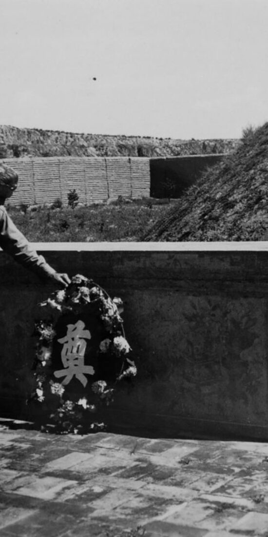
One photograph [L-708] captures Lowdermilk laying a wreath at the grave of Li Yizhi, “a friend of long standing,” who had shown Lowdermilk the Jinghui Canal project over 20 years before during an earlier of North China, when it was “out of commission because of silt.”

Here’s a photo of Li Yizhi’s tomb today.

http://blog.sina.cn/dpool/blog/s/blog_49b66ce201015oyd.html?vt=4
A comparison between the historical and contemporary photographs strikingly captures the transformation of the Jing River valley and the site of a diversion dam built as part of the Jinghui hydraulic engineering project in the 1930s (L-707), given that it has become the site of a large dam built in the late 1960s and heightened in the 1990s.


http://www.sohu.com/a/339639076_651611
As shown below, the Lowdermilk collection also has photos of the Luohui Canal’s Longshouba 龙首坝 (Dragon Head Dam), located on the boundary between Shaanxi’s Chengcheng County 澄城县 and Pucheng County 蒲城县. (The dam fell within the jurisdiction of Dali County 大荔县 during the 1930s and 1940s, Lowdermilk refers to it as the “Dan Li Irrigation Project.”)


Lowdermilk’s caption for the photograph (L-717) reads, “Shensi. Dah Li Irrigation Project. June 8, 1943. A view of the Dah Li diversion dam on the Loh Ho. The reservoir impounded by this dam 66 feet high was silted up in one rainstorm. The alluvial fill may be seen in the middle distance.”
The second image captures the current condition of the Dragon Head Dam and the surrounding landscape. There is a lot more to say about the Luohui Canal and the Jinghui Canal (as well as more photos to post), so I will write more about them in the near future.