
Lowdermilk Huajialing Photographs 1
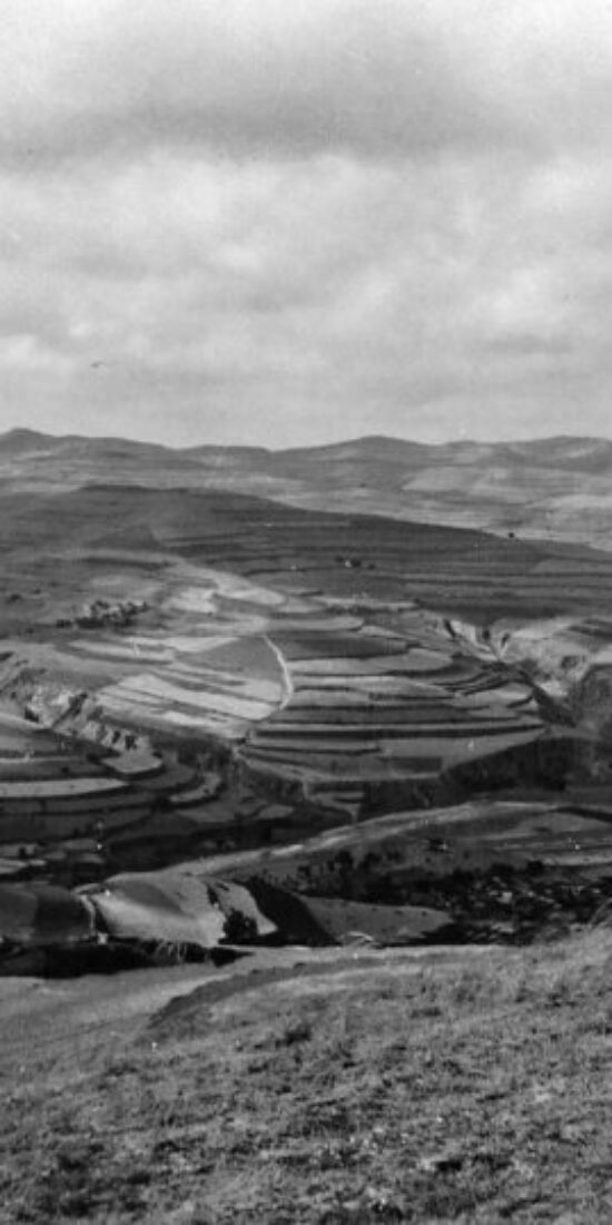
Many of the images in the Walter C. Lowdermilk collection at UC Berkeley’s Bancroft Library come from Huajialing 华家岭 in Gansu Province 甘肃省’s Tongwei County 通渭县, where Lowdermilk took numerous pictures of terraced slopes and gullies.

You can view a set of those photographs, which also contains some images of Rewi Alley‘s Bailie Vocational Institute and the Yellow River crossing near Lanzhou 兰州, by clicking the link below.
Walter C. Lowdermilk Lanzhou and Huajialing, Gansu Photographs
Walter C. Lowdermilk Qinghai Photographs
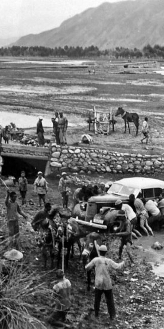
These two maps contain over 100 photographs taken in Qinghai 青海 by Walter C. Lowdermilk during his 1943 survey of northwest China.

In addition to some truly breathtaking vistas, the first set features images of the Yellow River, active sand dunes, Xi’ning 西宁, Qinghai Lake 青海湖, forest plantations, bench terraces, a station wagon stuck in the mud with local farmers helping to get it out (see above), some yaks, two “Tibetan belles” (see below), and a band of sheep and wool traders.


The highlights of the second set include photographs of the headquarters of military governor Ma Bufang 马步芳 and his armies (see above), along with herds of horses and flocks of sheep (see below), the breeding of which Ma encouraged on Qinghai’s vast grasslands.


Walter C. Lowdermilk Gansu Corridor Photographs

Click the link below to view an ArcGIS map containing 60 photographs taken by Lowdermilk in August 1943 while travelling in Northwest China’s Gansu corridor (河西走廊).
Walter C. Lowdermilk Gansu Corridor Photographs
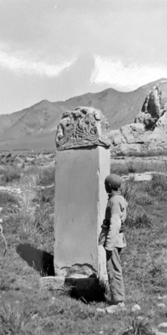
I am wondering about the stele pictured in the photo above, but have not researched the question in earnest. Caption reads:
Kansu Province, China. The Corridor. On the divide between the Yellow River and the Gobi Desert stands the ruins of a temple built at a guard station along the Great Wall. This monument describes the happenings along the Great Wall. Aug. 25, 1943
Walter C. Lowdermilk Sichuan Photographs 1
I have finished another ArcGIS map containing the photos that Lowdermilk took in Sichuan Province 四川省 before and during the first leg of his 1943 trip from southwest to northwest China. You can access the map via the link below.

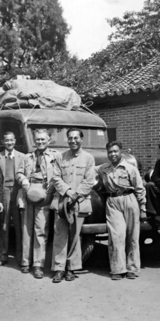
This photo of Lowdermilk taken with the rest of the investigation party [L-595] at the start of their trip has the caption: “Our survey party leaves Chengtu for the Northwest survey, with Messrs. Feng, Yieh, Chang, W. C. Lowdermilk, Liang, Lao Liu, and Djang. We are standing before the prized station wagon which the Ministry of Agriculture has purchased.”
Lao Liu 老刘 was their driver and I don’t know anything about him, but Lowdermilk listed the educational backgrounds and official positions of the other individuals appointed to the field party in his “Preliminary Report on Findings of a Survey of a Portion of the Northwest for a Program of Soil, Water and Forest Conservation” [1943].
I have inserted the Chinese names of the survey team members in the list of CVs that Lowdermilk provided, the governmental organs in which they served, and (wherever possible) links to their full biographies:
N.F. Chang [Zhang Naifeng 张乃凤], B.S. (Cornell University), M.S. (Agr.) University of Wisconsin. Chief, Department of Soils and Fertilisers [土壤肥料组], National Agricultural Research Bureau [农业实验所], Ministry of Agriculture and Forestry [农林部].
T.C. Tsiang [Jiang Deqi 蒋德麒], B.S. (University of Nanking [金陵大学]), M.S. (University of Minnesota). Senior Technician, National Agricultural Research Bureau, Ministry of Agriculture and Forestry.
Y.K. Liang [Liang Yongkang 梁永康], B.S. (National Chiao-tung University [国立交通大学]), M.S. (University of Michigan), Assistant Chief Engineer, Ministry of Agriculture and Forestry.
H.K. Fu [Fu Huanguang 傅焕光], B.S. (University of Philippine Islands). Senior Technician, National Forestry Research Bureau [中央林业实验所], Soil and Water Conservation Experimental Station [水土保持实验区], Ministry of Agriculture and Forestry.
P.C. Yieh [Ye Peizhong 叶培忠], B.S. (University of Nanking), M.S. (University of Edinburgh). Senior Technician, Soil and Water Conservation Experimental Station, Ministry of Agriculture and Forestry.
C.L. Feng [Feng Zhaolin 冯兆麟], B.S. (University of Nanking), Junior Technician, Soil and Water Conservation Experimental Station, Ministry of Agriculture and Forestry.
Y.C. Djang [Zhang Yuanxi 章元羲], B.S. (Polytechnical College, Tientsin [天津河北省立工业学院]) M.S. (Cornell University), Senior Technician, National Conservancy Board [水利委员会], Executive Yuan [行政院].
C. Chen [Chen Chi 陈迟], B.S. (University of Chekiang [浙江大学]), Senior Technician, Kansu Agricultural Improvement Bureau [甘肃农业改进所].
The biographies of these individuals clearly show that the planning and implementation of soil and water conservation programs in wartime China fell to mid-level bureaucrats, most of whom had received training abroad during the prewar period.
No less significantly, these Chinese specialists and the cosmopolitan science that they advocated continued to play a key role in the large-scale soil and water conservation initiatives undertaken after 1949 under the People’s Republic of China.
Walter C. Lowdermilk Huanglongshan photos

Almost a decade ago, I published an article in the Journal of Asian Studies (download it here) on migration, land use, and environmental change in a place in north-central Shaanxi Province 陕西省 called Huanglongshan 黄龙山.
During World War II, China’s Nationalist government resettled thousands of people displaced by Japan’s invasion of China and war-induced ecological disasters, such as the Nationalist army’s intentional diversion of the Yellow River and the 1942-43 Henan famine, to reclaim previouly abandoned “wasteland” for agricultural cultivation.
Eventually, the environmental effects of refugee resettlement and land reclamation in Huanglongshan became a key part of Chapters 2 and 5 of my book The Ecology of War in China: Henan Province, the Yellow River, and Beyond, 1938-1950.
Along with documents collected at the Shaanxi Provincial Archives in Xi’an, this research drew on the Walter C. Lowdermilk papers at the Hoover Institution Archives.
Only later did I discover that the Lowdermilk papers at UC Berkeley’s Bancroft Library has a collection of photographs that Lowdermilk took in 1943 while he was visiting Huanglongshan.
An interactive ArcGIS map of the photos from Huanglongshan can be accessed below:
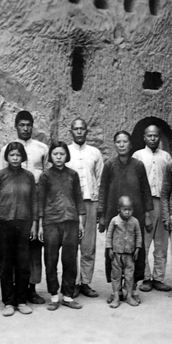
Walter C. Lowdermilk images from Tianshui, Gansu
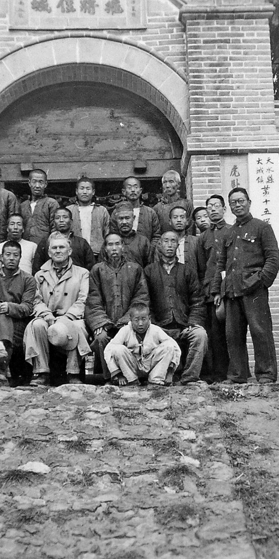

The Bancroft Library at the University of California, Berkeley holds a collection of nearly 800 historical photographs taken by the American soil and water conservation expert Walter C. Lowdermilk in 1943 during his investigative tour of northwest and southwest China.
These images document the agrarian environment and rural life in northwest and southwest China during the 1940s, as well as early conservation initiatives in the region.
I have digitized all of Lowdermilk’s China photographs from 1943 and geotagged them with spatial coordinates, which will make it possible to construct ArcGIS maps that display the photos at the specific sites at which they were taken.
To begin the project, I have put together two interactive maps that display over 150 photographs taken in Tianshui 天水 in eastern Gansu Province 甘肃省, where Lowdermilk oversaw the drawing up of preliminary plans for the Chinese Nationalist Government’s Tianshui Water and Soil Conservation Experiment Area 天水水土保持实验区 as an agricultural advisor to China’s Nationalist government.
You can access the two maps featuring Lowdermilk’s Tianshui images below:
Walter C. Lowdermilk Tianshui Photographs Map 1
Walter C. Lowdermilk Tianshui Photographs Map 2
These images accompany an article on the water and soil conservation programs launched in Tianshui by China’s Nationalist regime during the 1940s, which I recently published in the Journal of Modern Chinese History. You can download an open access version of the article here.
China Water and Soil History Network
The China Soil and Water History Network features research outcomes and source materials related to the history of land use, environmental change, and water and soil conservation in northwest China’s Loess Plateau region from the early-twentieth century to the present. The goal of the project is to facilitate systematic exploration of human interactions with soil and water as a fundamental component of Chinese environmental history. The research program and its online platform will present a variety of materials, including historical GIS, photographic images, archival documents, and quantitative data sets. These sources will make it possible to analyze relationships among the variables that have transformed the biophysical environment of the Loess Plateau across space and time, understand the consequences of these changes for human well-being, and evaluate the effects of water and soil conservation programs in the region. The purpose of this blog will be to serve as a forum for intellectual exchange and the dissemination of information related to this research program. It is also meant to facilitate and expand contributions to the project by a wider community of scholars and students.